Forum for kitesurfers
-
Toby
- Very Frequent Poster
- Posts: 50478
- Joined: Mon Sep 24, 2001 1:00 am
- Kiting since: 2000
- Weight: 95 kg
- Local Beach: Cumbuco, Brazil
Barra do Cauipe, Brazil
- Favorite Beaches: same
- Style: Airstyle
- Gear: Rebel 2015 18
- Brand Affiliation: None.
- Location: World (KF Admin)
-
Has thanked:
841 times
-
Been thanked:
2392 times
-
Contact:
Postby Toby » Wed May 15, 2019 10:05 pm
one question:
I saw graphics of the El Nino effect...looks like water heats up a lot...do you really feel a big difference in water temps in Peru and/or Ecuador?

- elnino.png (286.02 KiB) Viewed 943 times
https://images.app.goo.gl/pE9EUyRFbjf2Kb3WA
-
elguapo
- Very Frequent Poster
- Posts: 945
- Joined: Fri Jan 25, 2019 6:01 pm
- Favorite Beaches: pattaya
- Gear: ..
- Brand Affiliation: None
-
Has thanked:
0
-
Been thanked:
169 times
Postby elguapo » Wed May 15, 2019 10:26 pm
correct me if i'm wrong but doesnt el niño= much warmer temperatures in el caribe=more thermal winds in places like
buen hombre and cabarete? (and also much more violent weather in general in the hurricane zone
-
Toby
- Very Frequent Poster
- Posts: 50478
- Joined: Mon Sep 24, 2001 1:00 am
- Kiting since: 2000
- Weight: 95 kg
- Local Beach: Cumbuco, Brazil
Barra do Cauipe, Brazil
- Favorite Beaches: same
- Style: Airstyle
- Gear: Rebel 2015 18
- Brand Affiliation: None.
- Location: World (KF Admin)
-
Has thanked:
841 times
-
Been thanked:
2392 times
-
Contact:
Postby Toby » Wed May 15, 2019 11:09 pm
More catastrophic events world wide.
Hurricanes, tornados, dry weather in some places etc.
But this graphic makes it look like the water is much hotter than eg Brazil...and that’s already at 28°C
-
Toby
- Very Frequent Poster
- Posts: 50478
- Joined: Mon Sep 24, 2001 1:00 am
- Kiting since: 2000
- Weight: 95 kg
- Local Beach: Cumbuco, Brazil
Barra do Cauipe, Brazil
- Favorite Beaches: same
- Style: Airstyle
- Gear: Rebel 2015 18
- Brand Affiliation: None.
- Location: World (KF Admin)
-
Has thanked:
841 times
-
Been thanked:
2392 times
-
Contact:
Postby Toby » Thu May 16, 2019 12:55 am
So it’s confusing!
BTW, I love pink!
-
evan
- Very Frequent Poster
- Posts: 1186
- Joined: Sat Jan 31, 2004 5:48 pm
- Kiting since: 2002
- Local Beach: Brouwersdam
- Style: Hydrofoil - Big Air
- Gear: Infexion bars
- Brand Affiliation: Infexion
-
Has thanked:
14 times
-
Been thanked:
347 times
-
Contact:
Postby evan » Thu May 16, 2019 8:07 am
It is a "surface temperature anomaly map".
Showing the deviation of the temperature compared to the average surface temperature during an el nino event.
Don't confuse them with the actual measured temperatures, impossible to have the arctic seas warmer than the tropics

- These users thanked the author evan for the post:
- Toby (Thu May 16, 2019 9:47 am)
-
elguapo
- Very Frequent Poster
- Posts: 945
- Joined: Fri Jan 25, 2019 6:01 pm
- Favorite Beaches: pattaya
- Gear: ..
- Brand Affiliation: None
-
Has thanked:
0
-
Been thanked:
169 times
Postby elguapo » Thu May 16, 2019 11:54 am
evan wrote: ↑Thu May 16, 2019 8:07 am
It is a "surface temperature anomaly map".
Showing the deviation of the temperature compared to the average surface temperature during an el nino event.
Don't confuse them with the actual measured temperatures, impossible to have the arctic seas warmer than the tropics
ok.
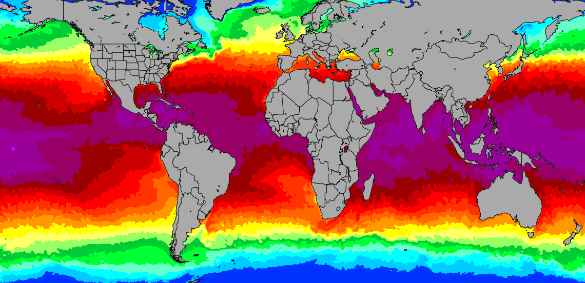
then here is a 'current' sea temperature anomaly map'..
(current as of this week)
Sea Surface Temperature (SST) Anomaly
SUMMARY: CRW's SST Anomaly is produced by subtracting the long-term mean SST (for that location in that time of year) from the current value. A positive anomaly means that the current sea surface temperature is warmer than average, and a negative anomaly means it is cooler than average. The spatial resolution is 0.5-degree (50-km), and the data and images are updated twice-weekly. Animations of the most recent SST Anomaly images are also available online.
CRW's near-real-time global SST Anomaly product makes it possible to quickly pinpoint regions of elevated SSTs throughout the world oceans. It is especially valuable for the tropical regions where most of the world's coral reef ecosystems thrive. It is also very useful in assessing ENSO (El Niño-Southern Oscillation) development, monitoring hurricane "wake" cooling, observing major shifts in coastal upwellings, etc.
A twice-weekly SST anomaly at a 0.5-degree (50-km) grid is calculated by subtracting the daily climatological SST of the last day of the twice-weekly period at that grid from the corresponding twice-weekly SST (described in Sea Surface Temperature Section). The formula for obtaining the anomaly is
SST_anomaly = SST - Daily_SST_climatology
The color range of temperature anomalies displayed on the SST Anomaly charts is -5.0 to +5.0 °C (or Kelvin). Areas with SST anomaly values less than -5.0 °C are displayed as -5.0 °C, and areas with values greater than +5.0 °C are displayed as +5.0 °C. Note that these anomalies are somewhat less reliable at high latitudes where more persistent clouds limit the amount of satellite data available for deriving accurate SST analysis fields and climatologies.
Data and images of both near-real-time and archived SST anomalies are available from the CRW website, along with the operational 0.5-degree monthly mean SST climatologies. Animations of SST Anomaly images for the past six months are also available.
Charts of the retrospective 1984-1998 monthly mean SST anomalies are available online at 36-km resolution.
-
JakeFarley
- Very Frequent Poster
- Posts: 920
- Joined: Sun Nov 27, 2016 11:54 pm
- Kiting since: 2001
- Weight: 92kg
- Local Beach: Florida Left Coast, USA
- Favorite Beaches: Any that are not crowded.
- Style: Dinosaur style (Velociraptor)
- Gear: Kites: Flysurfer Speed5 21m, Soul 12m, Cabrinha 16m Xbow, 11m Xbow, Best 14m HP Nemesis, 9m Yarga C Hybrid
Boards: Crazyfly 135 x 46 Pro, Cabrinha Spoiler 140, 6' custom surfboard, 122 x 46 custom twintip
Wing foil: Naish Hover 110l, Slingwing 6.4m, F-One CWC Strike 8m, Slingshot Hover Glide Fwing (Infinity 99), Slingshot Phantasm 926 and E 990
- Brand Affiliation: None
- Location: Pearl City
-
Has thanked:
187 times
-
Been thanked:
144 times
Postby JakeFarley » Fri May 17, 2019 1:00 am
elguapo wrote: ↑Wed May 15, 2019 10:26 pm
correct me if i'm wrong but doesnt el niño= much warmer temperatures in el caribe=more thermal winds in places like
buen hombre and cabarete? (and also much more violent weather in general in the hurricane zone
From what I've read, El Nino produces more wind shear in the Atlantic ocean and Carribean sea resulting in less hurricane formation. I've noticed that we sometimes have a windier summer here on the west coast of Florida during El Nino years.
Return to “Kitesurfing”
Who is online
Users browsing this forum: adiver, ak200, Aleza, andrzej351, Google [Bot], ham-er, i_love_storm, IDAVIS, IWB2, jjm, mede, Pemba, Regis-de-giens, rocketcapetown, thewindego, tilmann, VElars, Xtream, Yahoo [Bot] and 313 guests